Breadcrumb
Gallery
The Changing Geography of the Ottoman Empire (1300–1920) (en español)
Maps showing the growth and contraction of territory controlled by the Ottoman Empire from 1300 through 1920. This resource is in Spanish.
Last Updated:
This resource is intended for educators in the United States who are applying Spanish-language resources in the classroom.
La transformación geográfica del Imperio Otomano (1300–1920)
Maps showing the growth and contraction of territory controlled by the Ottoman Empire from 1300 through 1920.
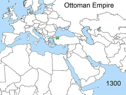






Ottoman Empire, 1300
This map shows the territory controlled by the Ottoman Empire in 1300.
Credit:
Esemono / Wikimedia Commons
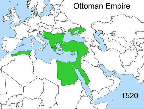
Ottoman Empire, 1520
This map shows the territory controlled by the Ottoman Empire in 1520.
Credit:
Esemono / Wikimedia Commons
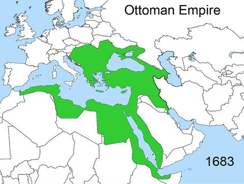
Ottoman Empire, 1683
This map shows the territory controlled by the Ottoman Empire in 1683.
Credit:
Esemono / Wikimedia Commons
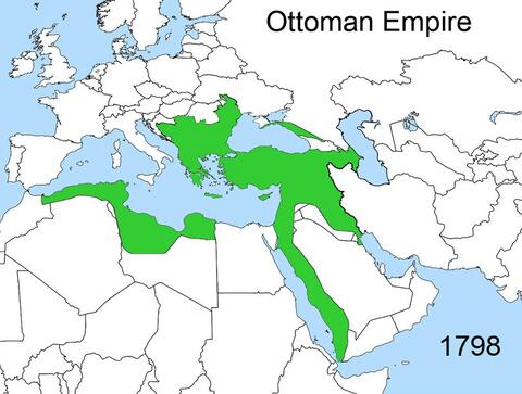
Ottoman Empire, 1798
This map shows the territory controlled by the Ottoman Empire in 1798.
Credit:
Esemono / Wikimedia Commons
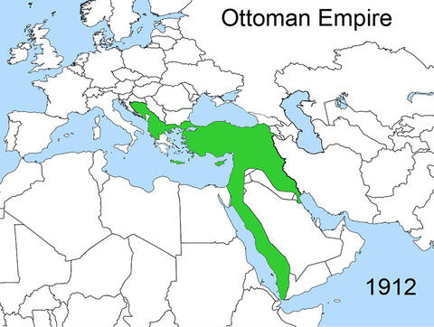
Ottoman Empire, 1912
This map shows the territory controlled by the Ottoman Empire in 1912.
Credit:
Esemono / Wikimedia Commons
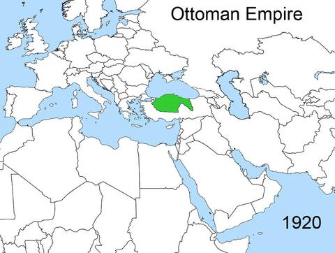
Ottoman Empire, 1920
This map shows the territory controlled by the Ottoman Empire in 1920.
Credit:
Esemono / Wikimedia Commons
You might also be interested in…
Chapter
Guardar
Appartenance
Examinez comment les identités autochtones du Canada ont été façonnées par la façon dont les colons européens ont répondu aux différences réelles et perçues entre eux et les Peuples Autochtones.

Unit
Guardar
Americans and the Holocaust: The Refugee Crisis
Explore the motives, pressures, and fears that shaped Americans’ responses to Nazism and the humanitarian refugee crisis it provoked during the 1930s and 1940s.

Collection
Guardar
Holocaust and Human Behavior
Explore the digital version of our core resource on the Holocaust. Find classroom-ready readings, primary sources, and short documentary films that support a study of the Holocaust through the lens of human behavior.

Mini-Lesson
Guardar
Genocide Still Happens
Use this mini-lesson to reflect with your students on what we can do to stop ongoing atrocities and prevent future genocides.

Chapter
Guardar
La Loi sur les Indiens et les pensionnats
Comprenez l’histoire derrière la législation et les politiques élaborées par le gouvernement du Canada au XIXe siècle, dont l’objectif était de déposséder culturellement les Peuples Autochtones et de les assimiler.

Chapter
Guardar
L'expérience des pensionnats
Lisez des témoignages de première main racontant les expériences souvent douloureuses et profondément dommageables que les Survivants et Survivantes ont connues dans les pensionnats autochtones.

Chapter
Guardar
Excuses
Renseignez-vous sur les excuses présentées aux Peuples Autochtones par le gouvernement et les églises du Canada, et examinez le rôle des excuses dans la justice transitionnelle.

Chapter
Guardar
Vérité et réconciliation
Examinez la Commission de vérité et de réconciliation du Canada ainsi que le rôle qu’elle joue pour aider les individus et la nation à surmonter le traumatisme et l’injustice historique du système des pensionnats autochtones.

Chapter
Guardar
L'histoire à la recherche d'un nom
Étudiez le débat qui a abouti à une déclaration caractérisant de « génocide culturel » les politiques coloniales du gouvernement canadien à l’égard des Peuples Autochtones.

Chapter
Guardar
Choix civiques
Découvrez les efforts entrepris par les dirigeants et les militants qui défendent les droits et la culture des Peuples Autochtones, y compris les jeunes qui utilisent leur histoire et leur culture pour bâtir des ponts vers les autres et vers l’avenir.

Lesson
Guardar
Teaching with Video Testimony
Students watch video testimony from a Holocaust survivor and engage in purposeful reflection about the survivor’s important story.

Lesson
Guardar
Western Imperialism and Nation Building in Japan and China
Students are introduced to the history of Western imperialism in East Asia and its influence on the identities and ambitions of Japan and China.
Using the strategies from Facing History is almost like an awakening.
—
Claudia Bautista, Santa Monica, Calif

